
The Afar front of the 2026 Tigray war: ten days below the escarpment
· 2026-09-22 – 2026-10-03
This analysis is for education and research. Content on ongoing wars may change as new information emerges. We label claims separately from confirmed facts.
Overview (BLUF)
On 22 September 2026 the Tigray Defence Forces (TDF), fighting alongside the Afar armed group Ugugumo, came down the escarpment on the eastern edge of the Tigray highlands and took Abala. On the 27th they took Erebti, a little over 100 km further on by road. The federal side did not send forces to Afar first. It struck Alamata in the south on 27–28 September, and on 1 October it retook Abala, Erebti and Megale with the Tigray Peace Force (TPF). By the 3rd the Tigrayans were entirely out of Afar (sources 2, 8, 9).
This column makes three judgements.
- The main aim of the eastward push was likely (55–80%) to put pressure on the Djibouti corridor (the A1 road) and gain leverage. A fixing attack meant to hold federal forces away from the decisive southern front is unlikely (20–45%). Our confidence in this judgement is low: no Tigrayan source states the Afar objectives, and one of the key items of evidence rests on a single source.
- The direction of the pressure and the actual threat must be kept apart. Even at Erebti, the deepest point reached, the A1 was still about 180 km away in a straight line (our calculation). An ACLED analyst also judged on 28 September that the corridor remained open (source 5). A cut of the A1 within days at the end of September was very unlikely (5–20%).
- The federal side treated Afar as an economy-of-force sector and put its main effort on the southern A2 axis. Once Alamata fell, the Afar salient collapsed in little more than three days. This sequence is our reconstruction from the dates; the federal side has never stated its plan.
Background and Strategic Context
Clashes along the Afar–Tigray boundary continued after the 2022 Pretoria agreement. In November 2025 the Afar regional administration claimed that TPLF fighters had crossed the boundary, taken six villages and fired mortars in Megale district (source 16). Low-intensity fighting between the TPLF and the Ethiopian National Defence Force (ENDF) ran from 1 August 2026, and from early September the TDF deployed tanks and artillery in Southern Tigray (source 1).
On 20 September seven groups, among them the TPLF, Fano, an Oromo Liberation Army faction and Ugugumo (the Afar Revolutionary Democratic Unity Front, ARDUF), formed the Ethiopian Peoples' Forces Alliance for Survival (EPFAS) (sources 1, 7). Two days later the TDF opened several fronts at once. On the 23rd it seized the airports at Mekelle, Aksum and Shire and fought alongside Fano on the Kobo–Tumuga axis. The Afar push began the same night (sources 1, 2).
Afar carries Ethiopia's economic lifeline. The Djibouti corridor handles almost all of the country's international trade and fuel imports (source 4). In 2021 the TDF had also entered Afar and was assessed to be aiming at the road and railway to Djibouti; its spokesman at the time said the aim was to degrade the enemy's fighting capability, not to gain territory (sources 17, 18).
Terrain and Weather
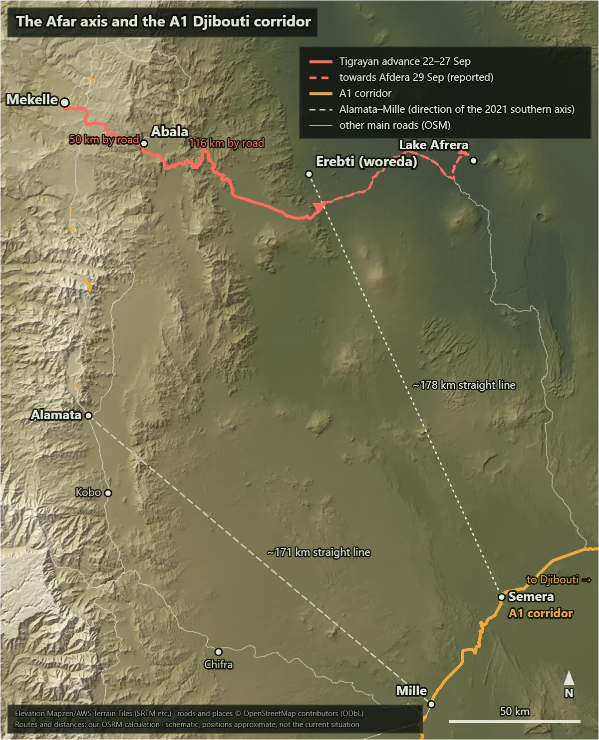
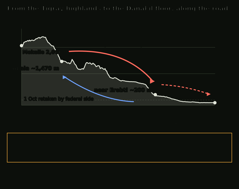
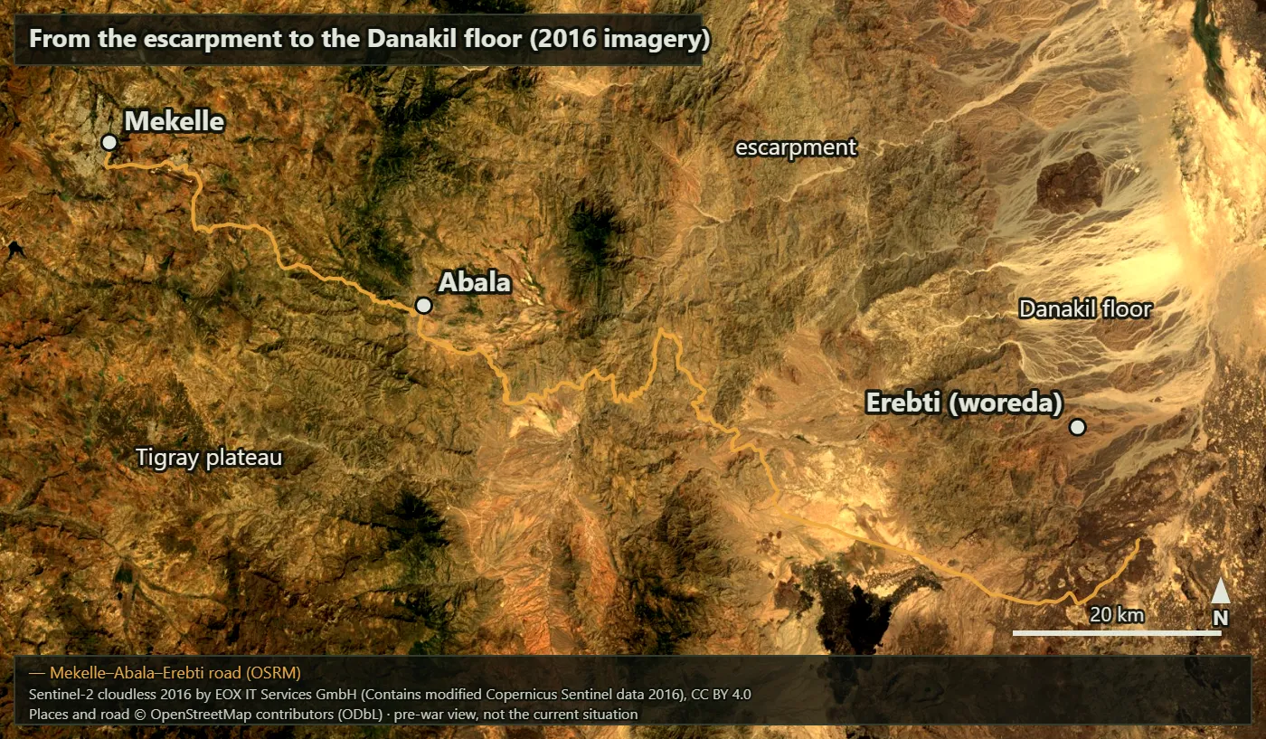
The Tigray plateau around Mekelle stands a little over 2,000 m. Eastwards the ground steps down along the escarpment to the Afar Depression (the Danakil), which falls below sea level (figures 1, 3). Measured along the road, the route crosses a ridge east of Mekelle (about 2,420 m) and then drops some 950 m in a little over 20 km to Abala. From Abala to Erebti it drops another 1,300 m or so (figure 2).
The figures below are our own calculations from OpenStreetMap (OSM) place coordinates, the OSM road network (OSRM routing) and SRTM elevation. They are not reported figures (sources 21–24).
| Leg | Straight line | Road (OSRM) | Elevation (start → end) |
|---|---|---|---|
| Mekelle → Abala | 34 km | 50 km | 2,066 m → 1,465 m (ridge en route ~2,420 m) |
| Abala → Erebti | 64 km | 116 km | 1,465 m → ~170–200 m |
| Abala → Lake Afrera (Afdera area) | 125 km | 190 km | → −112 m |
| Erebti → Semera (A1) | 178 km | – | → 432 m |
| Erebti → Mille (A1) | 208 km | – | |
| Lake Afrera → Semera | 168 km | 241 km | |
| Alamata → Mille (direction of the 2021 southern axis) | 171 km | 238 km |
The Erebti coordinate is the woreda (district) centre, not the town. Its elevation is about 170 m at the woreda centre and about 200 m at the nearest point on the road, so it depends on where you measure. Geocoding put Afdera town in the wrong place, so Lake Afrera stands in for it. AFP reported Abala to Erebti as "about 100 km", broadly in line with our 116 km (source 3).
A terrain analysis (OAKOC) gives the following.
- Observation and fields of fire: the escarpment overlooks the lowland for a long way. Vehicles coming up from below have almost nowhere to hide.
- Cover and concealment: the depression is sparsely vegetated desert. Concealment is concentrated in the ravines of the escarpment and in villages.
- Obstacles: the escarpment itself is the obstacle. Few roads climb it, and vehicles and supply are tied to them.
- Key terrain: Abala is a road junction on an intermediate step below the plateau. In spring 2022 the Semera–Abala–Mekelle road was the only open road into Tigray (sources 19, 20). Whoever holds Abala holds Mekelle's eastern gate.
- Avenues of approach: the eastern approach is the desert route through Abala, Erebti and Afdera, then south to the A1. The southern approach runs from Alamata and Kobo east through Chifra to Mille; it was used in 2021. Alamata to Mille is about 171 km in a straight line, little different from Erebti to Semera (about 178 km), but this route branches straight off the A2 on the plateau.
We found no 2026 source on temperatures or water in the depression in late September. The terrain alone shows, though, that a drop of more than 1,000 m puts a heavier heat and water burden on the attacker (inference).
Forces and Dispositions
Neither side has published strengths or unit designations for the Afar front, and no independent source gives them. The order of battle is unknown. Open sources tell us who fought, and little more.
- Tigrayan side: ACLED recorded the TDF and Ugugumo fighting together on 22, 23 and 29 September (source 2). On 26 September ACLED named the TPLF, Fano and Ugugumo as the three alliance members actually fighting (source 7). Another Afar group appears on the alliance list, but its part in the fighting is unconfirmed (source 15).
- Federal side: the force recorded fighting in Afar Zone 2 on 22–23 September was the TPF (source 2), a unit of former TDF and TPLF fighters now on the government side (source 10). AFP reported that federal forces had been based at Abala in recent months (source 3). The recapture of 1–2 October was carried out by government troops and an "associated militia" (sources 2, 8). The Afar regional special forces, the main defenders in 2021, are not named in any 2026 source.
- Drones: the federal side used drones throughout the war, with up to 17 strikes on Alamata on 22 September. We found no record of strikes on Abala or Erebti (source 2).
Course of the Action
| Date (2026) | Afar axis | Source and nature |
|---|---|---|
| 22 Sep | Fighting around Abala, Megale, Wosema and Erebti; Abala reported taken | ACLED; AFP (foreign security source) [2, 3] |
| 22–23 Sep | Former TPLF official claims six places, including Berahle and Dallol | Party claim; AFP could not confirm [3] |
| 23 Sep | Fighting continues in Zone 2; new front at Tonsa on the Tigray–Afar boundary | ACLED [2] |
| 25 Sep | Fighting spreads south to Yallo (Zone 4) | ACLED [2] |
| 27 Sep | Erebti falls after heavy artillery fire | Humanitarian source; ACLED [2, 4] |
| 27–28 Sep | Federal side takes Alamata in the south | ACLED [2] |
| 29 Sep | Advance from Erebti towards Afdera reported | ACLED only [2] |
| 30 Sep | Federal side takes all of Raya Bala woreda, about 40 km from Mekelle; more than 80,000 Afar residents trapped | ACLED; Al Jazeera [2, 6] |
| 1 Oct | Federal forces and TPF retake Abala, Erebti and Megale | ACLED; Reuters as cited [2, 6] |
| 2–3 Oct | Tigrayans entirely out of Afar; federal side takes Mekelle airport | AFP [8, 9] |
The action falls into two phases.
- Descent and expansion (22–27 September): Abala, below the first escarpment, was taken first, and within six days the Tigrayans had gone down to Erebti on the lowland. Fighting reached Yallo in the south, so the push was not on a single line.
- Collapse of the salient (28 September–3 October): once Alamata fell and federal forces closed on Mekelle, the Afar salient gave way in little more than three days. No source tells us whether Abala was retaken by assault or vacated first.
Decision Point Analysis
Decision 1: opening the Afar front (TDF command, 22 September) The options were (a) defend on the escarpment, (b) a limited attack on Abala only, or (c) open the Afar front on the same night as the other fronts and go down to the lowland. The TDF chose (c). It came two days after the alliance was formed, and Ugugumo could supply both guides and political cover. Clearing the federal garrison 50 km east of Mekelle also appears to have been part of the calculation. Abala fell on the first day.
Decision 2: how to answer in Afar (federal command, 22–23 September) The options were (a) reinforce the Abala garrison and hold on the escarpment, or (b) leave Afar to the TPF and local forces and keep the main effort in the south. No reinforcement is recorded and the TPF keeps appearing, so the choice appears to have been (b): economy of force, giving up ground in Afar to mass at the decisive point.
Decision 3: whether to go further down (TDF, 23–27 September) The options were (a) stop at Abala and hold the intermediate step, or (b) go down another 1,300 m or so to Erebti. The TDF chose (b) and took Erebti on the 27th. The price was a supply line 116 km longer, a single road down the escarpment into the desert.
Decision 4: betting on the south first (federal command, 27–28 September) The options were (a) counterattack the Afar salient first, or (b) commit to Alamata and the A2 axis first. The federal side chose (b) and took Alamata, the point where the southern axis branches off the A2 on the plateau. With that point closed, the eastern salient appears to have been exposed on its flank and rear.
Decision 5: go on or turn back (TDF, 29 September) With the south collapsing, the options were (a) keep advancing towards Afdera and the A1, or (b) pull forces out of Afar to defend Mekelle. ACLED recorded an advance towards Afdera on the 29th. If that is right, the TDF held to (a) for another day or two, either because orders were slow to arrive or because it wanted to keep a bargaining threat to the last. No source lets us tell which.
Decision 6: when to retake Afar (federal command, 30 September–1 October) The options were (a) take Mekelle first and deal with Afar later, or (b) retake Afar and advance on Mekelle together. With the TPF in the lead, the federal side retook Abala, Erebti and Megale on 1 October and entered Mekelle airport two days later: in effect (b). Holding Abala again opened the eastern road to Mekelle and closed the Tigrayans' eastern line of retreat.
Decision 7: giving up Afar and Mekelle (TDF, 1–3 October) The options were (a) a delaying action at Abala and on the escarpment, or (b) leave Afar and Mekelle without a fight. The Tigrayans left Afar entirely and gave up Mekelle without a major battle (sources 9, 11). Sources disagree on whether Mekelle was left on the 3rd or the 4th (source 11). It looks like a decision to preserve the force, but no source gives the command's reasons.
Analysis of Competing Hypotheses (ACH): why east?
We followed Richards Heuer's ACH procedure (sources 26, 27). The hypotheses concern the main aim of the Tigrayan push into Afar.
- H1: threaten or cut the Djibouti corridor (A1) to gain leverage.
- H2: secure the Mekelle–Abala–Semera road as Tigray's eastern supply line and pre-empt a blockade.
- H3: fix federal forces away from the decisive southern front (Alamata, Kobo).
- H4: show that the alliance is multi-ethnic by fighting alongside Ugugumo.
- H5: link up with Eritrea or open an outside supply route via the Afar–Eritrea border.
- H6: seize economic assets such as the Abala market or salt and potash.
Only evidence that is inconsistent (I) with at least one hypothesis stays in the matrix. C means consistent, I inconsistent, N not applicable. The ratings are our own.
| Evidence | Credibility | H1 | H2 | H3 | H4 | H5 | H6 |
|---|---|---|---|---|---|---|---|
| E1. Advance to Erebti by 27 September: 116 km by road from Abala and a drop of about 1,300 m, heading east (Afdera), not north towards Berahle and Dallol [2, 4] | High | C | N | C | N | I | I |
| E2. Heavy artillery used in the attack on Erebti [4] | Medium (one source) | C | N | C | I | N | N |
| E3. Advance towards Afdera reported after Alamata fell (27–28 September) [2] | Medium (ACLED only) | C | N | I | N | I | N |
| E4. All three places lost on 1 October and Afar left entirely by the 3rd, with no sign of an attempt to hold [2, 8, 9] | High | N | I | C | N | N | I |
| Inconsistencies (I) | 0 | 1 | 1 | 1 | 2 | 2 |
What we dropped, and why: the simultaneous opening of several fronts, Ugugumo's participation and the federal garrison at Abala are consistent with, or irrelevant to, every hypothesis, so they cannot separate them. The former TPLF official's claim to Berahle and Dallol, and the Afar authorities' claim that Eritrean troops had entered Afar, are consistent only with H5, but both are unconfirmed party claims and stay out of the matrix (see Quality of Information below).
Reading the matrix. H1 has the fewest inconsistencies: the direction in E1 and the continued advance in E3 both fit it. H3 falls on E3 alone: if the aim had been to draw federal forces away from the south, the reason to push deeper vanished once Alamata fell. H2 falls on E4: an attacker securing a supply line would not give up Abala so easily. H4 falls on E2: showing off an alliance does not need a 100 km push into the lowland backed by heavy artillery. H5 and H6 fail on the direction of the advance itself (E1).
Sensitivity check. Two items could overturn the judgement.
- E3 (the advance towards Afdera on 29 September) is recorded only by ACLED. If the advance in fact stopped at Erebti on the 27th, H3 loses its only inconsistency, and H1 and H3 become a roughly even chance (45–55%).
- If the capture of Berahle and Dallol, or Eritrean troops in Afar, were independently confirmed, it would mean the Tigrayans were aiming north as well as east. That weakens E1's inconsistency with H5, which would need to be re-examined.
Conclusion. Likelihood terms follow the seven-band scale of ICD 203 (source 28): almost no chance (1–5%), very unlikely (5–20%), unlikely (20–45%), roughly even chance (45–55%), likely (55–80%), very likely (80–95%), almost certain (95–99%).
- That the main aim was H1 (pressure on the A1) is likely.
- H3 (fixing in the south) is unlikely.
- H2 (eastern supply line), H4 (alliance signalling) and H5 (link with Eritrea) are each very unlikely.
- H6 (economic assets) has almost no chance.
H1 and H3 do not exclude each other: an attack towards the A1 also ties down federal forces. The judgement above is about which was the main aim.
Our confidence is low. No Tigrayan source states the 2026 Afar objectives; the only statements of intent come from ACLED and reports citing it; and we could not read CTP's daily reviews.
Key Assumptions Check
| Assumption | Why we hold it | Rating | What would show it wrong |
|---|---|---|---|
| Afar was a supporting effort, not the TDF main effort | Several fronts opened at once, the penetration was shallow, and the salient collapsed straight after Alamata | Caveated | An order of battle or prisoner statements showing brigade-size or larger main forces in Afar |
| ACLED alert dates match events to within about a day | They agree with AFP, Euronews and Al Jazeera reporting | Solid | Primary reporting dating the recapture of Abala before 30 September |
| Erebti is about 180 km from the A1 (Semera) in a straight line | Our own calculation from OSM coordinates; woreda centre, and about 166 km from the nearest road point | Caveated | Erebti town lying more than 30 km closer to the A1 than the woreda centre |
| The TPF was the main federal ground force in Afar | ACLED names only the TPF on 22–23 September and 1 October | Caveated | Independent reporting of ENDF division-level units committed in Afar |
| No Eritrean troops fought in Afar in late September | Only Afar officials say so and Reuters could not confirm; the confirmed Eritrean entry was further north, around Adigrat, on 7–8 October | Unsupported | Satellite imagery or two or more independent outlets confirming Eritrean troops in Afar in late September |
| The federal sequence was a planned economy of force | Inferred from the order of dates (Alamata → Raya Bala → Afar → Mekelle) | Caveated | Records of division-level reinforcement sent to Afar between 22 and 30 September |
The ratings are our own three-step scale: solid (backed by several sources), caveated (some basis, with conditions), unsupported (too weak to lean on).
Quality of Information
- Party claims: a former TPLF official's claim to Berahle, Dallol, Konoba and other places (AFP could not confirm) [3]; a government-side figure's description on the 23rd of an "all out offensive" against government positions in Afar and Amhara [3]; the Afar authorities' claim of Eritrean troops in Afar (Reuters could not confirm) [6]. Government forces told Reuters on 1 October they had retaken the towns; this was unconfirmed at the time and confirmed by AFP, citing a humanitarian source, the next day [6, 8].
- Single source: the 29 September advance towards Afdera and the intent "to cut the Djibouti supply line" come from ACLED alone [2]. The artillery fire at Erebti comes from one humanitarian source [4]. The figure of at least 150,000 displaced in Afar is one humanitarian source's estimate, which AFP said it could not confirm [4].
- Second-hand: CTP's 30 September wording about Abala "and other A2 positions" was seen only as quoted on Wikipedia; Abala is not on the A2, so the wording is doubtful [15]. CTP and France 24 originals were blocked and only search summaries were read [9, 14]. We did not see the 2026 Reuters texts directly.
- Not used: a projection of 400,000 displaced in Afar (original not seen) and an 11–12 October report of an advance to within 50 km of Assab (denied by Afar sources).
Forecast: the Afar axis over the next one to three months
Since mid-October the federal side has held Mekelle and, on 16 October, announced a six-month caretaker administration for Tigray (source 12). On the 23rd a caretaker official urged the rebels to disarm while a TDF commander vowed to fight on, and drone strikes on Mekelle continued (source 13). The same day CTP reported that the TPLF had retaken a town on the Eritrean border vacated during a federal redeployment (search summary, source 14). Ethiopia and Eritrea cut diplomatic ties on 1 October (source 6).
Three scenarios to the end of January 2027:
- S1. The Afar axis stays quiet: the TDF holds out with irregular warfare inside the highlands and does not come back down to the lowland. Likely.
- S2. Small raids resume around the escarpment: the TDF or Ugugumo repeatedly raid and ambush roads below the escarpment near Abala. Unlikely.
- S3. Afar becomes an axis of inter-state conflict: Ethiopia and Eritrea clash on the Afar–Eritrea border or along the A1. Very unlikely.
Our confidence is low: no open source shows the TDF's remaining strength or federal dispositions.
Four signposts to watch:
- Fighting recorded in Afar Zones 2 and 4: if ACLED's daily alerts show two or more clashes a week in Zone 2 or Zone 4 for two weeks running before 31 December, the picture tilts towards S2.
- Ugugumo reappearing: if Ugugumo or EPFAS announces an Afar operation, or ACLED records Ugugumo fighting, before 30 November, that points to S2.
- Inter-state fighting on the A1 or the border: if two or more independent outlets such as Reuters or AFP confirm a large federal build-up along the A1 or fighting on the Afar–Eritrea border before 31 January 2027, shift to S3.
- Traffic resuming on the eastern road: reports before 31 December of regular humanitarian convoys on the Semera–Abala–Mekelle road would firm up S1.
Lessons
- Terrain and the culminating point: going down 1,300 m adds more sustainment burden than the distance alone suggests. The terrain profile shows an attacker's culminating point before the map distance does.
- Economy of force and the decisive point: the federal side gave up ground in Afar for a while and put its main effort on the decisive point of the southern axis. The salient fell apart once its flank was open.
- Separate direction from capability: reports of an "attempt to cut the A1" describe the direction of intent. The real threat has to be measured separately, by the distance left and the supply behind it.
Limits of the Method
ACH and the key assumptions check let others follow and check our reasoning; they do not guarantee that the conclusion is right. RAND has noted that intelligence agencies rely heavily on such techniques yet have rarely evaluated them systematically (source 29). In a 2019 experiment that randomly assigned 50 analysts, the evidence that ACH reduces confirmation bias was mixed, and there were signs it can make judgements less consistent (source 30). The matrix ratings and likelihood bands in this column are our judgements, not computed probabilities.
Sources
- ACLED, expert comment on the TPLF move on critical sites and the new alliance (2026-09-23). https://acleddata.com/expert-comment/tplf-move-critical-sites-after-heading-new-alliance-new-phase-next-war (accessed 2026-10-27)
- ACLED, Ethiopia alerts archive (entries for 22 September–3 October 2026). https://acleddata.com/ethiopia-alerts-archive (accessed 2026-10-27)
- Africanews/AFP, Tigray forces seize airports as fighting spreads to Afar (2026-09-23). https://www.africanews.com/2026/09/23/ethiopia-tigray-forces-seize-airports-as-fighting-spreads-to-afar/ (accessed 2026-10-27)
- Euronews, Tigray rebels push into Afar as Ethiopia blames neighbours (2026-09-28). https://www.euronews.com/2026/09/28/tigray-rebels-push-into-afar-as-ethiopia-blames-neighbours (accessed 2026-10-27)
- Euronews (French edition), the same story with comment from an ACLED analyst (2026-09-28). https://fr.euronews.com/2026/09/28/les-rebelles-du-tigre-avancent-en-afar-lethiopie-accuse-ses-voisins (accessed 2026-10-27)
- Al Jazeera, blasts heard in Addis Ababa as the conflict widens in the north (2026-10-01). https://www.aljazeera.com/news/2026/10/1/blasts-heard-in-addis-ababa-as-ethiopia-conflict-widens-in-the-north (accessed 2026-10-27)
- Al Jazeera, how the fighting spread beyond Tigray, in maps and charts (2026-10-02). https://www.aljazeera.com/news/2026/10/2/how-the-fighting-in-ethiopia-spread-beyond-tigray-in-maps-and-charts (accessed 2026-10-27)
- Le360/AFP, Tigrayan forces pushed out of Afar (2026-10-02). https://afrique.le360.ma/politique/ethiopie-les-forces-du-tigre-repoussees-par-larmee-federale-hors-de-la-region-afar-voisine_KJIKF6JDHFGOBJZAS53JL7L4JI/ (accessed 2026-10-27)
- France 24/AFP, Tigray rebels abandon Mekelle (2026-10-03; blocked, search summary only). https://www.france24.com/en/africa/20261003-ethiopia-s-tigray-rebels-abandon-regional-capital-of-mekelle-as-pro-government-forces-advance (accessed 2026-10-27)
- Africanews, federal forces advance in Tigray (2026-10-05). https://www.africanews.com/2026/10/05/ethiopia-federal-forces-advance-in-tigray-africanews-today/ (accessed 2026-10-27)
- Security Council Report, Horn of Africa closed consultations (2026-10). https://www.securitycouncilreport.org/whatsinblue/2026/10/horn-of-africa-closed-consultations.php (accessed 2026-10-27)
- Christian Science Monitor, the caretaker administration in Tigray after Mekelle (2026-10-16). https://www.csmonitor.com/World/Africa/2026/1016/ethiopia-tigray-mekelle-war-caretaker-administration (accessed 2026-10-27)
- Al Jazeera, Tigray official urges rebels to disarm (2026-10-23). https://www.aljazeera.com/news/2026/10/23/tigray-official-urges-rebels-to-disarm (accessed 2026-10-27)
- Critical Threats (CTP), Ethiopia War Security Review (2026-10-23; blocked, search summary only). https://www.criticalthreats.org/briefs/ethiopia-war-security-review/october-23-2026 (accessed 2026-10-27)
- Wikipedia, TPLF insurgency in Ethiopia (compilation used for cross-checking; the Reuters, BBC and CTP originals it cites were not seen). https://en.wikipedia.org/wiki/TPLF_insurgency_in_Ethiopia (accessed 2026-10-27)
- Al Jazeera (via Yahoo), claim of Tigrayan fighters entering Afar (2025-11-06). https://www.yahoo.com/news/articles/tigray-fighters-enter-ethiopia-afar-112146892.html (accessed 2026-10-27)
- ACLED, Ethiopia Peace Observatory weekly (2021-07-31 to 08-06). https://acleddata.com/update/epo-weekly-31-july-6-august-2021 (accessed 2026-10-27)
- Al Jazeera, Tigray forces enter Afar (2021-07-19). https://www.aljazeera.com/news/2021/7/19/ethiopias-tigray-forces-enter-neighbouring-afar-region (accessed 2026-10-27)
- VOA/USAGM, the only open road into Tigray (2022-05). https://direct.usagm.gov/record/134633 (accessed 2026-10-27)
- WFP USA, Semera–Abala–Mekelle convoy reaches Tigray (2022). https://wfpusa.org/news/wfp-convoy-reaches-tigray/ (accessed 2026-10-27)
- Wikipedia, Abala, Ethiopia (coordinates and geography). https://en.wikipedia.org/wiki/Abala,_Ethiopia (accessed 2026-10-27)
- Wikipedia, Erebti (woreda) (coordinates and geography). https://en.wikipedia.org/wiki/Erebti_(woreda) (accessed 2026-10-27)
- OpenStreetMap contributors, places and roads (Nominatim, Overpass API, OSRM routing; ODbL). https://www.openstreetmap.org/copyright (accessed 2026-10-27)
- Elevation data: Open-Elevation (SRTM) and Mapzen/AWS Terrain Tiles. https://github.com/tilezen/joerd/blob/master/docs/attribution.md (accessed 2026-10-27)
- EOX IT Services, Sentinel-2 cloudless 2016 (CC BY 4.0). https://s2maps.eu (accessed 2026-10-27)
- CIA Center for the Study of Intelligence, Psychology of Intelligence Analysis, chapter 8 (ACH). https://www.cia.gov/resources/csi/static/Pyschology-of-Intelligence-Analysis.pdf (accessed 2026-10-27)
- CIA, A Tradecraft Primer: Structured Analytic Techniques (2009-03). https://www.cia.gov/resources/csi/static/Tradecraft-Primer-apr09.pdf (accessed 2026-10-27)
- Office of the Director of National Intelligence, ICD 203 Analytic Standards (2015, amended 2022). https://archive.dni.gov/files/documents/ICD/ICD-203.pdf (accessed 2026-10-27)
- RAND, report RR-1408 assessing structured analytic techniques (2016). https://www.rand.org/pubs/research_reports/RR1408.html (accessed 2026-10-27)
- Applied Cognitive Psychology vol. 33, controlled experiment on ACH (2019). https://strathprints.strath.ac.uk/69049/ (accessed 2026-10-27)