
Battle of Sniper Ridge (1952): getting through the first night on a ridge just taken
· 1952-10-14 – 1952-11-25
This analysis is for education and research. Content on ongoing wars may change as new information emerges. We label claims separately from confirmed facts.
Command this battle yourselfIn-depth part 2 →Battle of Sniper Ridge in depth: why the crest retaken by day did not last the nightHow the decision points in this analysis are adjudicated → · Glossary
Overview (BLUF)
On 14 October 1952 the 3rd Battalion, 32nd Regiment, ROK 2nd Division attacked Sniper Ridge north of Kumhwa. US IX Corps' Operation Showdown was a limited attack: one American and one ROK battalion, five days. The battalion took the ridge that afternoon and by night had been pushed off everything except Dolbawi Hill. From then until mid-November the ROK climbed the ridge by day and the Chinese came back by night. When the ROK 9th Division took over on 25 November, the ROK held Hill A and Dolbawi Hill, and the Chinese held the tunnels of Hill Y at the northern end.
Taking the ridge was the easier half of the problem. The harder half was the first night afterwards, and three conditions decided it: the hours left before sunset, the tunnels that were never cleared, and enemy artillery that counter-battery fire could not silence.
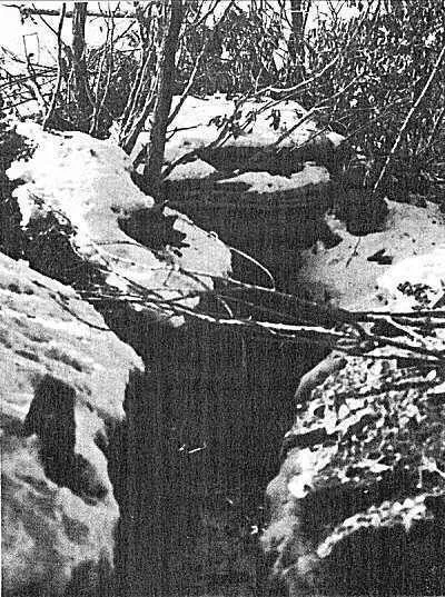
Background and Strategic Context
By the autumn of 1952 the Panmunjom talks had stalled and the Communists were stepping up attacks on outposts. General Van Fleet, commanding the US Eighth Army, judged that sitting on the defensive was costing more casualties than at any time since autumn 1951, and proposed small attacks to win back the initiative. North of Kumhwa the lines were about 180 m apart. If the enemy could be pushed off Triangle Hill (Hill 598) and Sniper Ridge, the argument ran, he would have to drop back about 1,140 m to his next position (source 1).
The plan was modest: a battalion each from the US 7th and ROK 2nd Divisions, five days, about 200 casualties. Support was to be 16 artillery battalions with some 280 guns and more than 200 fighter-bomber sorties. But the five days of air preparation shrank to two because of White Horse Hill, and artillery support was cut as well (source 1). To the Chinese 15th Army the ridge was a step towards Osong-san. A column drawing on veterans' accounts says they feared that losing Osong-san would put the Pyonggang area at risk (source 5).
Terrain and Weather
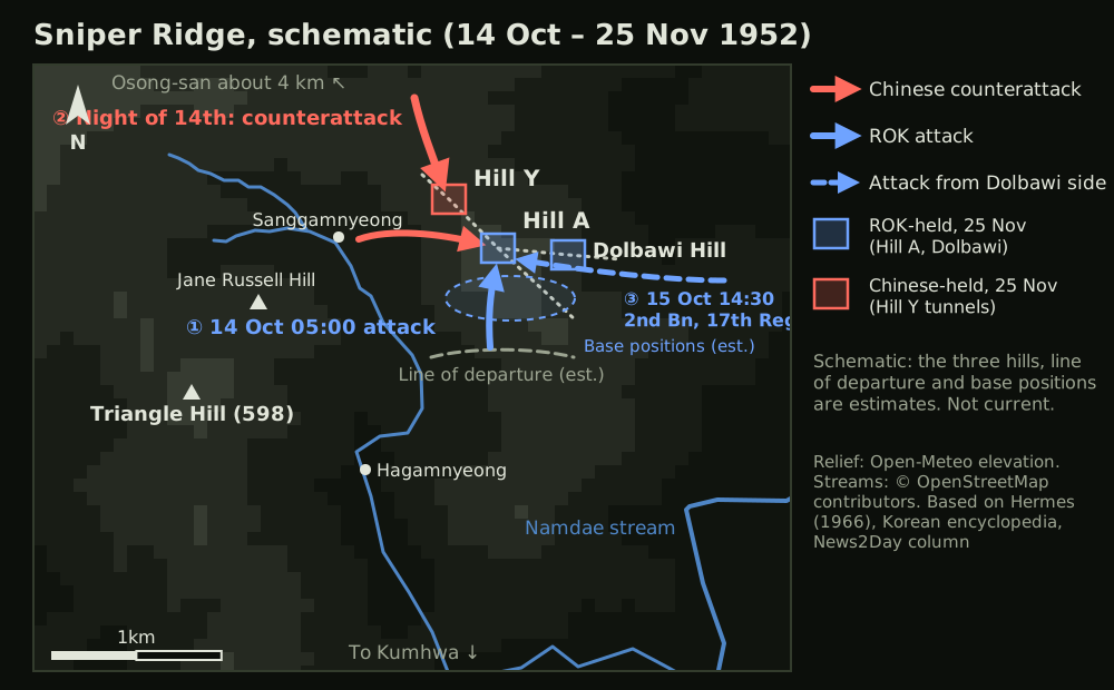
Sniper Ridge is a salient spur among the ridges running down from Osong-san towards Kumhwa, rising near the Namdae stream. It stands about 580 m above sea level, covers about 1 km² and lies north-west to south-east, roughly 2 km north-east of Triangle Hill (sources 1, 4). The ROK called the main peak Hill A, the northern end Hill Y, and the peak on the eastern spur Dolbawi Hill (source 5). No open source gives exact coordinates for the three, so their positions in Figure 1 are estimates.
The ground favoured the Chinese. Osong-san (1,062 m) looked down on the whole ridge and Hill Y looked down on Hill A (sources 5, 6). The slope facing the attackers was steep; a veteran remembers 70 to 80 degrees, possibly an exaggeration (source 5). Chinese-based accounts say the 15th Army had dug about 9 km of tunnels as well as trenches (one-sided claim, source 8). Fire could sweep the crest and still leave men underground.
Reanalysis data put sunset at about 17:54 on 14 October and about 17:11 on 25 November (our calculation, source 12). A ridge taken at 15:20 left a little over two and a half hours of light. Rain and moonless nights added to that. The attack of 21 October came in a blinding rainstorm (source 9).
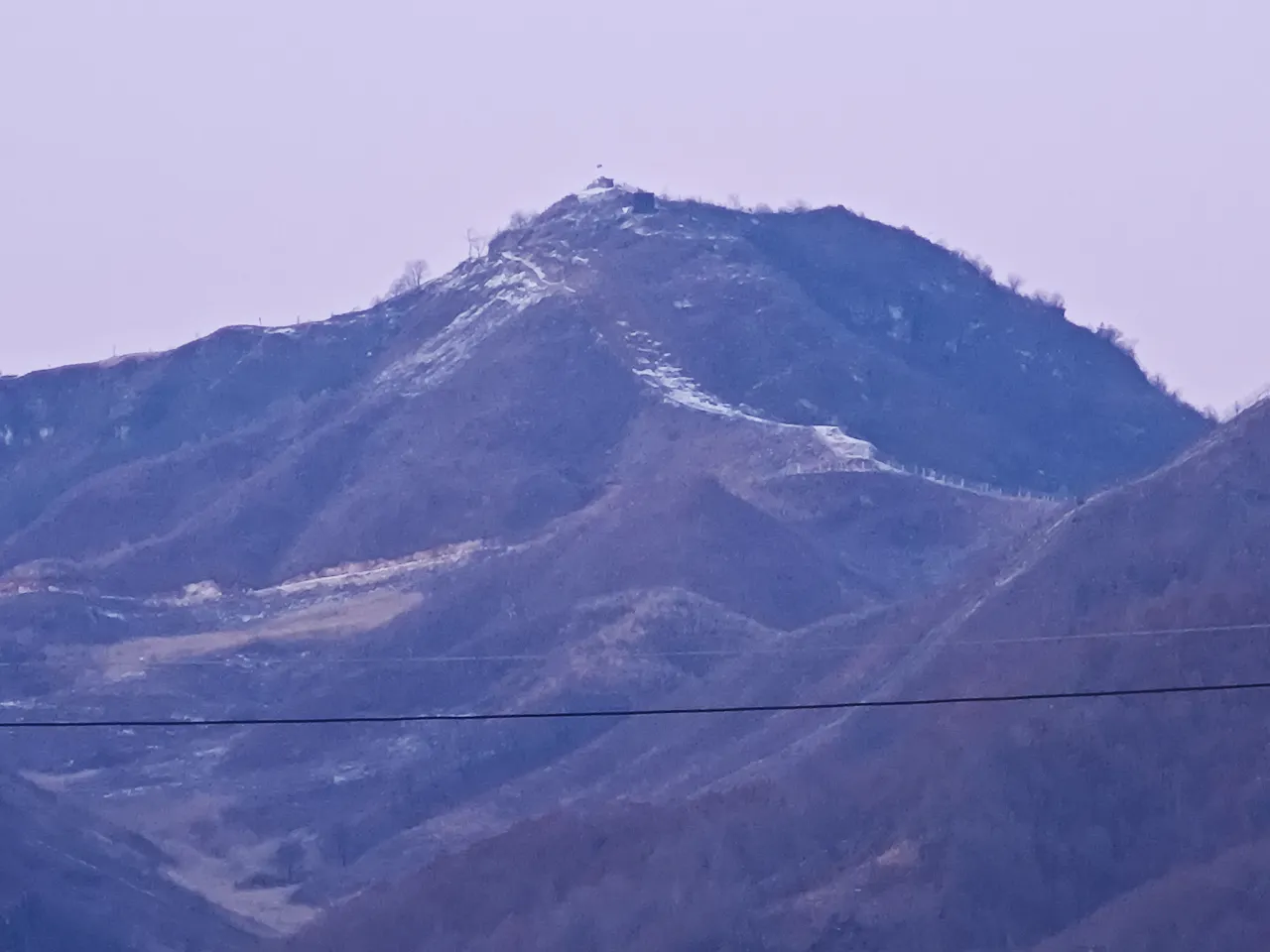
Forces and Dispositions
- ROK 2nd Division: commanded by Chung Il-kwon, under the operational control of US IX Corps. The 32nd and 17th Regiments took turns on the ridge. When the division took over the US 7th Division's sector on 25 October, the 31st Regiment went to Triangle Hill, the 32nd to Sniper Ridge and the 17th into reserve (the column; an English-language account has the 17th staying on the ridge, sources 1, 5, 8). Nine artillery battalions fired for the first attack (source 5).
- Chinese: the 45th Division, 15th Army, held the area first. Chinese records put the reinforced 1st Company, 135th Regiment (280 men) on the ridge. The 133rd, 134th and 135th Regiments carried the counterattacks, followed in November by the 92nd, 93rd and 106th Regiments of the 12th Army (partly one-sided, sources 5, 8).
Chinese accounts say that at the start they held only the northern peak and the UN already had the southern one. Korean accounts treat the whole ridge as a Chinese outpost (source 8). Which record you follow changes what "retaking" means.
Course of the Action
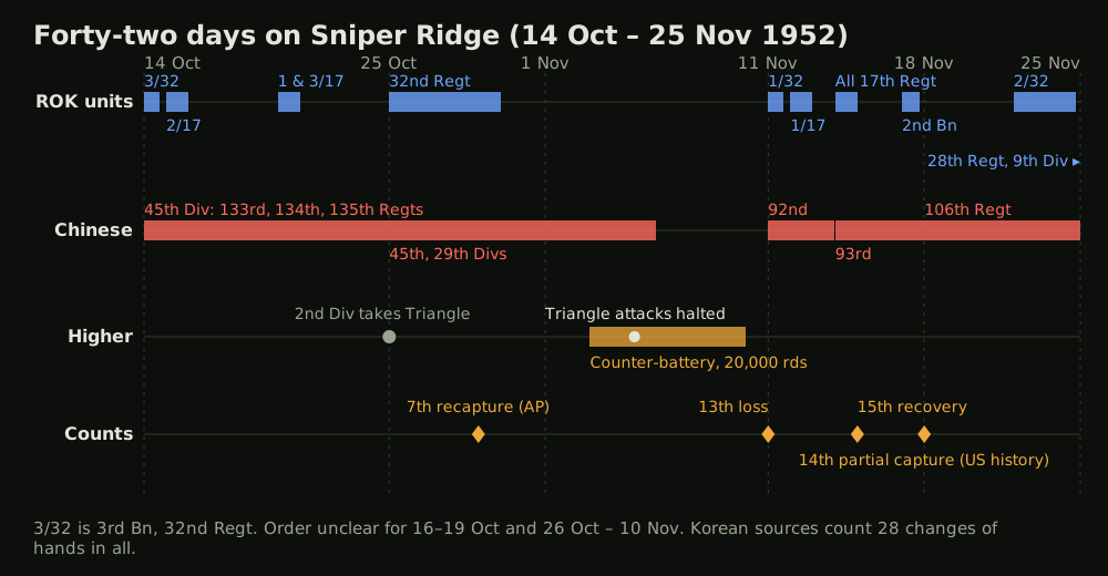
- First attack and first night (14 October): at 05:00 the 3rd Battalion, 32nd Regiment went forward as the preparation lifted. The encyclopedia puts the shells at close to 50,000 (source 4). The first assault did not get over the crest. At 13:40, reinforced by a company and supported by six flights of fighter-bombers, it attacked again and took the ridge (source 5). The time of capture varies from 15:20 (a secondary English-language account) to about 17:00 (a veteran's memory). That night Chinese shelling and wave attacks overran the tactical command post, and only Dolbawi Hill was left.
- Retaken by day, lost by night (15–29 October): at 14:30 on the 15th the 2nd Battalion, 17th Regiment retook Hill A under covering fire from Dolbawi. The sources disagree on the order after that (sources 4, 5, 8). On the 20th the attack was stopped three times and reached Hill A only after 76 close air support sorties (source 5). On the 24th the ROK gave up clearing the northern tunnels (source 10), and on the morning of the 29th they retook the crest for the seventh time in 16 days (source 11).
- Counter-battery fire and the loss of Triangle Hill (30 October – 10 November): on the 30th the ROK stayed about 45 m from the summit to escape the shelling (source 11). The same day the Chinese retook Hill 598 on Triangle Hill, and on 5 November the corps commander stopped attacks there (source 1). In the week from 3 November counter-battery fire of about 20,000 rounds put out of action 39 artillery pieces and 19 anti-aircraft guns (source 2).
- The last exchanges (11–18 November): at about 16:00 on the 11th the Chinese 92nd Regiment attacked and pushed off the 1st Battalion, 32nd Regiment, and the ROK fell back to their base positions (sources 8, 11). On the 12th the 1st Battalion, 17th Regiment retook the ground, and at 23:10 on the 13th about 1,000 men took it again. On the 14th the 17th Regiment committed every unit, and on the 15th it regained the crest (sources 8, 11). The encyclopedia dates the securing of Hill A to the 18th (source 4).
- Relief (18–25 November): attacks shrank to probes. The 2nd Battalion, 32nd Regiment deployed in depth and stopped the last attack, and at about 09:00 on the 25th the 28th Regiment, ROK 9th Division took over (source 5). The US official history dates the relief to the 24th (source 3).
Korean figures for ROK losses are 1,096 dead, 3,496 wounded and 97 missing (a secondary English-language account has 1,906 dead, sources 6, 8). None has been independently verified. The US official history gives over 9,000 UN casualties and an estimated 19,000 or more Chinese for the whole operation, Triangle Hill included (source 1). UN casualties alone were more than 40 times the 200 in the plan.
Decision Point Analysis
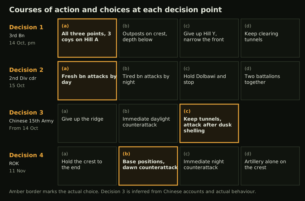
Decision 1: the layout before dark (3rd Battalion, 32nd Regiment, afternoon of 14 October), scenario phase 3 The courses were (a) hold all three points with the weight on Hill A, (b) outposts on the crest with the main body in depth below it, (c) give up Hill Y and narrow the front, (d) keep clearing the tunnels. The battalion chose (a), with one company each on Hill Y and Dolbawi and three on Hill A (source 5). No source gives the reason. Given a mission to take the crest and the time left, the likeliest explanation is that men who had reached the top simply stayed there. The night's shelling fell on the massed troops, and Hills A and Y were lost.
Decision 2: a fresh battalion by day (ROK 2nd Division commander, 15 October), scenario phase 5 From (a) relieve with a fresh battalion and attack by day under cover from Dolbawi, (b) a night attack by the tired battalion, (c) hold Dolbawi and stop, (d) commit two battalions together, the commander chose (a). Holding Dolbawi allowed fire into the flank of Hill A, and Hill A was retaken at 14:30. The price was the timetable. From this day the plan of two battalions and five days was effectively over, and attrition by rotating battalions took its place.
Decision 3: keep the tunnels and return at night (Chinese 15th Army, from 14 October) Chinese operational records were not available, so this is read from behaviour. The options were (a) give up the ridge, (b) counterattack immediately by day, (c) leave men in the tunnels and counterattack after dusk shelling. Option (c) recurred, probably because UN firepower dominated the daylight. Its weakness was that the hour became predictable, so the ROK prepared for dusk and timed their flares and searchlights for it (source 9). Chinese accounts say the commander of the 106th Regiment changed the formula in November (one-sided claim, source 8).
Decision 4: go down to base positions and strike at dawn (ROK, 11 November), scenario phase 7 Of (a) hold the crest to the end, (b) fall back to base positions and counterattack at dawn with a fresh battalion, (c) counterattack at once at night, (d) block the crest with artillery alone, what happened was (b). The AP says the ROK had held the base positions through 12 earlier withdrawals (source 11). The dawn counterattack was the division's decision, given to the 17th Regiment. Losing the crest did less harm when a position to spend the night in lay behind it, because the next day's attack had somewhere to start.
Lessons
- Taking the objective starts the defensive work: the US 7th Division commander reported that troops must dig in and build overhead cover at once (source 1). FM 3-90 defines consolidation as organising and strengthening a captured position to use against the enemy (para 1-123, source 7).
- Fire does not reach underground: observers estimated about 50 rounds of accurate fire to destroy one gun (source 2). Tunnels left uncleared kept the attack's starting point intact.
- Keep reserves within a night's reach: in rough terrain reserves must stay close to the front, the same report says (source 1).
- Review the intent and the cost together: the two-battalion, five-day plan was shaken on the first day. When an operation's cost runs well past the original estimate, whether to go on has to be weighed again, even while tactical successes continue.
- Relief belongs to the fight: on 2 December, after the relief, the enemy again briefly held the outposts on the crest (source 3). The weaknesses of a position pass over along with it.
Sources
- Walter G. Hermes, Truce Tent and Fighting Front, ch. XIII, US Army Center of Military History, 1966, pp. 310–318. https://web.archive.org/web/2016/http://www.history.army.mil/books/korea/truce/ch13.htm (accessed 2026-10-31)
- Same work, ch. XVI, pp. 352–353. https://web.archive.org/web/2016/http://www.history.army.mil/books/korea/truce/ch16.htm (accessed 2026-10-31)
- Same work, ch. XVII, pp. 368–369. https://web.archive.org/web/2016/http://www.history.army.mil/books/korea/truce/ch17.htm (accessed 2026-10-31)
- Academy of Korean Studies, Encyclopedia of Korean Culture, "저격능선전투". https://encykorea.aks.ac.kr/Article/E0049082 (accessed 2026-10-31)
- News2Day, Kim Hee-chul column on the Sniper Ridge and Sanggamnyeong battles, part 2 (with veterans' accounts), 2020-11-06. https://www.news2day.co.kr/article/20201106163742 (accessed 2026-10-31)
- News2Day, the same column, part 1, 2020-11-04. https://www.news2day.co.kr/article/20201104163518 (accessed 2026-10-31)
- US Army, FM 3-90 Tactics, 2023 (para 1-123). https://armypubs.army.mil/epubs/DR_pubs/DR_a/ARN38160-FM_3-90-000-WEB-1.pdf (accessed 2026-10-31)
- Chae Han Kook et al., The Korean War, vol. III (2001), pp. 467–472, and Chinese accounts, as cited secondhand. Cross-checked through the English and Chinese Wikipedia articles; the book itself was not checked directly. https://en.wikipedia.org/wiki/Battle_of_Triangle_Hill , https://zh.wikipedia.org/wiki/%E4%B8%8A%E7%94%98%E5%B2%AD%E6%88%98%E5%BD%B9 (accessed 2026-10-31)
- AP reports in summary (The Charlotte News, 1952-10-18 and 10-21, modern editor's summary). https://wjcash.org/WJCash20/Charlotte.News.Articles/10-18-52.htm , https://wjcash.org/WJCash20/Charlotte.News.Articles/10-21-52.htm (accessed 2026-10-31)
- AP report in summary (The Charlotte News, 1952-10-24). https://wjcash.org/WJCash20/Charlotte.News.Articles/10-24-52.htm (accessed 2026-10-31)
- AP reports in summary (The Charlotte News, 1952-10-29, 10-30, 11-11, 11-13, 11-15). https://wjcash.org/WJCash20/Charlotte.News.Articles/10-29-52.htm , https://wjcash.org/WJCash20/Charlotte.News.Articles/10-30-52.htm , https://wjcash.org/WJCash20/Charlotte.News.Articles/11-11-52.htm , https://wjcash.org/WJCash20/Charlotte.News.Articles/11-13-52.htm , https://wjcash.org/WJCash20/Charlotte.News.Articles/11-15-52.htm (accessed 2026-10-31)
- Open-Meteo, Historical Weather API (ERA5 reanalysis), Sniper Ridge grid cell, 1952-10-13 to 11-25. https://archive-api.open-meteo.com/v1/archive?latitude=38.33&longitude=127.485&start_date=1952-10-13&end_date=1952-11-25&daily=temperature_2m_max,temperature_2m_min,precipitation_sum,sunrise,sunset&timezone=Asia%2FSeoul (accessed 2026-10-31)
- Wikimedia Commons, File:Chinese Bunker On Sniper Ridge.jpg (unknown author, PD-South Korea). https://commons.wikimedia.org/wiki/File:Chinese_Bunker_On_Sniper_Ridge.jpg (accessed 2026-10-31)
- Wikimedia Commons, File:Triangle Hill view from South Korea.jpg (董辰兴, CC BY-SA 4.0). https://commons.wikimedia.org/wiki/File:Triangle_Hill_view_from_South_Korea.jpg (accessed 2026-10-31)

