
Battle of Sniper Ridge in depth: why the crest retaken by day did not last the night
· 1952-10-14 – 1952-11-25
In-depth part 2 · preview; full text with Individual Plus
This analysis is for education and research. Content on ongoing wars may change as new information emerges. We label claims separately from confirmed facts.
Command this battle yourself← Part 1 overviewBattle of Sniper Ridge (1952): getting through the first night on a ridge just takenHow the decision points in this analysis are adjudicated → · Glossary
Overview
Part 1: Battle of Sniper Ridge (1952) covered the broad course of the 42 days and four decisions. This part follows one question: why did the ROK lose by night the Hill A they retook by day, and why did they stop losing it after 18 November? It sets the length of the day, the moon and the rain against the calendar, sorts out which battalion was on the ridge when, and then goes through the training scenario's phases p1 to p9 and its seven what-if phases. The evidence does not support naming a single cause for the end of the struggle. Positions below the crest and deployment in depth clearly helped the defenders through the night, but enemy pressure also fell from mid-November [1][4]. Much of the battalion-level account rests on retellings, not the official text, and the source criticism section deals with that separately.
Strategic and operational context
On 8 October 1952 the UN delegation recessed the Panmunjom plenary talks indefinitely, and the same day General Clark, the UN commander, approved Van Fleet's Showdown plan [1][9]. Clark had opposed hill-taking before, but according to the official history he judged that this plan had a better than average chance of success at low cost. He told Van Fleet to give it only routine press coverage [1]. US IX Corps' aim was to improve its line north of Kumhwa. Push the enemy off Triangle Hill and Sniper Ridge and he would have to drop back about 1,140 m, and the two sides would no longer overlook each other from about 180 m [1].
The calculation had two gaps. The first was firepower. It assumed 16 artillery battalions with about 280 guns and over 200 fighter-bomber sorties, yet White Horse Hill, then being fought to the west, cut five days of air preparation to two and reduced the artillery as well [1]. The second was the enemy's judgement. The 15th Army thought that losing Osong-san would endanger the Pyonggang area, says a column drawing on veterans' accounts [5]. What was an outpost adjustment for the corps was the last ground before the main line for the other side. Chinese-based accounts also say an ROK 2nd Division staff officer brought over the attack plan on 5 October and that it was not taken seriously [8][9]. They disagree on whether he defected or was captured, and it could not be confirmed in Korean or US sources, so it carries no weight here.
The plan soon came apart. On 25 October the 2nd Division took over the US 7th Division's Triangle Hill sector as well, and on 5 November the corps commander, General Jenkins, stopped attacks on Triangle Hill [1]. The division carried on fighting for Sniper Ridge. The official history sums up the result as holding only "a portion" of the ridge [1].
Terrain and weather in detail (OAKOC)
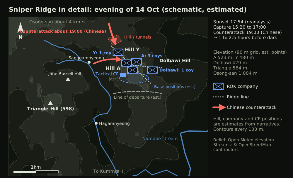
Observation and fields of fire. The ridge is given as about 580 m (encyclopedia) to 590 m, and the northern peak, which Chinese sources call Hill 537.7, is lower [4][9]. A 90 m elevation model at the estimated positions returns 523 m around Hill A, 480 m around Hill Y and 429 m around Dolbawi, with 1,004 m for Osong-san [31]. The coordinates are estimates and the grid shaves summits, so only the order of heights is useful. Osong-san lies about 4 km north-west of the ridge (our calculation). The official history says the two sides looked down each other's throats [1].
Avenues of approach. The ROK climbed the southern slope. A veteran recalls a gradient of 70 to 80 degrees and a slope 500 to 600 m long [5]. Those figures may be exaggerated, but his account that the enemy firing from above caused heavy losses fits the ground. The Chinese had three routes: out of the Hill Y tunnels from the north, up the western slope from the Sanggamnyeong valley, and from the east as on the evening of 13 November [25]. The AP describes the attack of 11 November as coming from the north, east and west [23].
Key terrain. The battle is named after the ridge, but the fight was over Hill A. The AP calls Pinpoint Hill the dominant height on the ridge and bases its counts on it [23][27]; equating Pinpoint with Hill A is an inference. Judging by what happened in November, Hill Y was the real wedge. The attack of the 13th came from there, and that is where the enemy returned on the 15th [25][27].
Obstacles. The slope and the wreckage of shelling mattered more than anything man-made. One account says the preparation stripped the trees and destroyed most positions above ground [8]. After that the slopes were probably bare earth with no cover. Timber and sandbags for overhead cover would have had to be carried up from below.
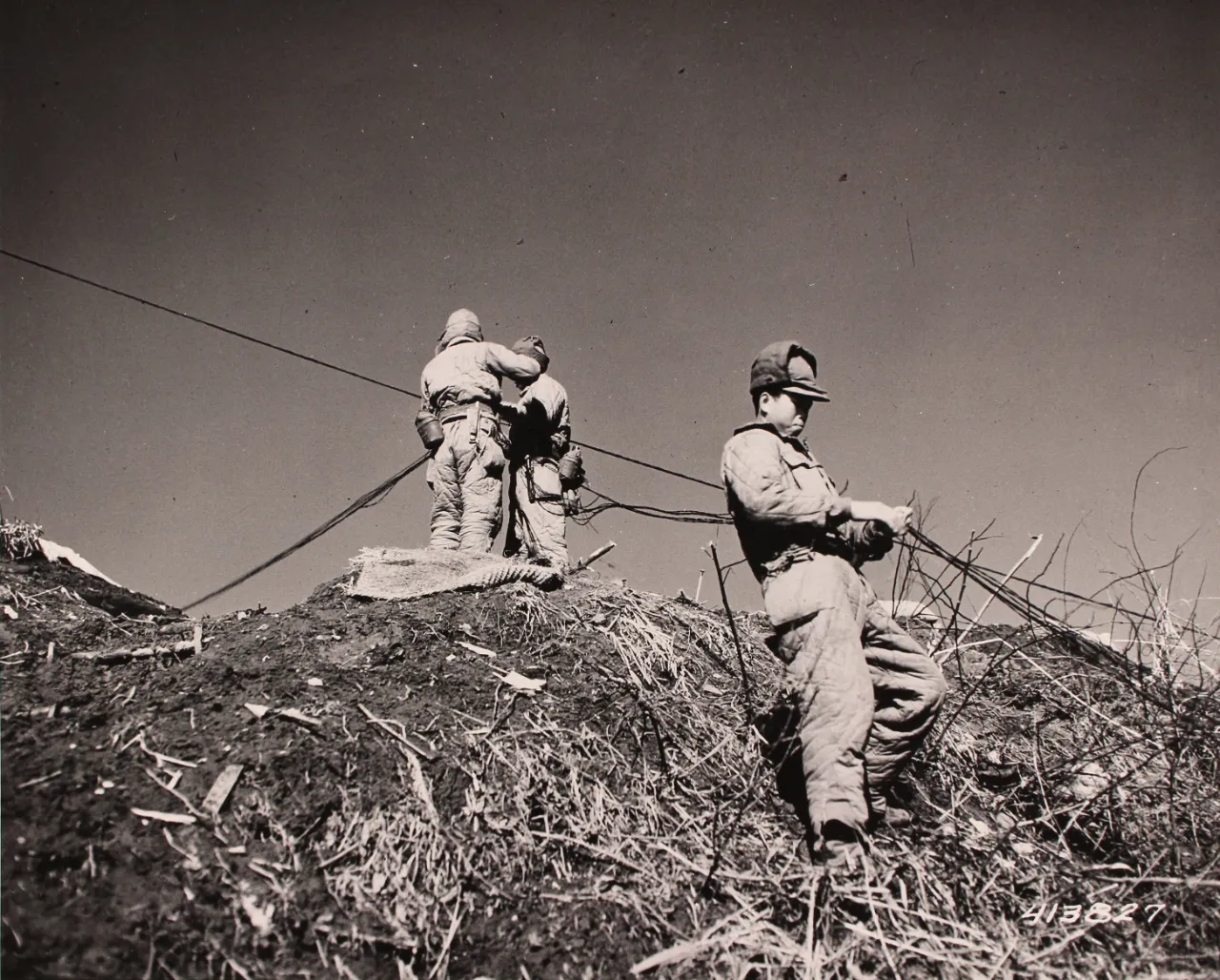
Cover and concealment. The 15th Army is said to have dug about 9 km of tunnels and about 50 km of trenches [8]. That is a one-sided claim, but it agrees with what US observers found. It took about 50 rounds of accurate fire to put out one gun, and in a week about 20,000 rounds damaged or destroyed more than 250 emplacements but only 39 artillery pieces and 19 anti-aircraft guns [2]. For ROK battalions that changed often on a crest that kept changing hands, overhead cover was probably a job that could never be finished.
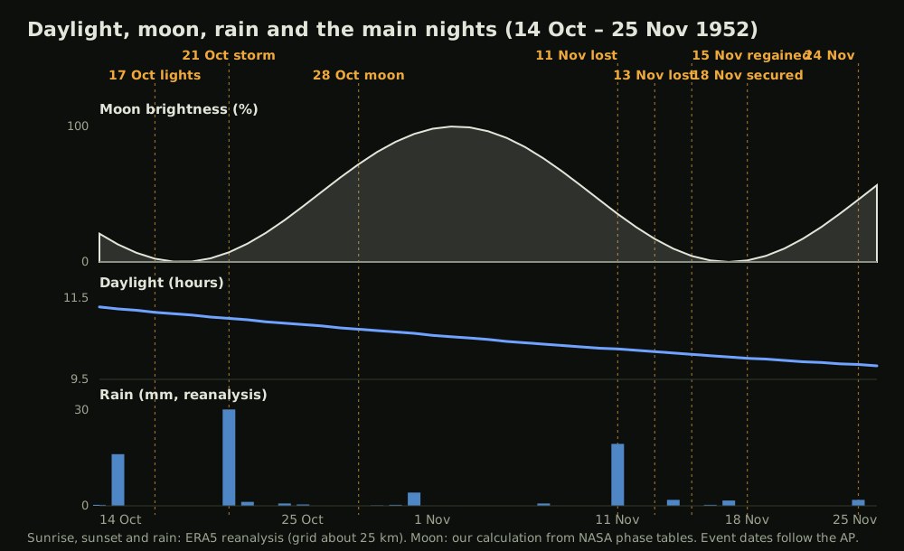
Daylight, moon, rain. The table and Figure 2 set AP reports against reanalysed weather and astronomical data. Sunrise, sunset and rainfall are low-resolution ERA5 estimates, and moonlight is calculated from NASA's phase tables [30][32].
| Date (Korean time) | Daylight | Moon, evening | Rain (reanalysis) | That night |
|---|---|---|---|---|
| 14 Oct | 11 h 17 min | 21% | 0.3 mm | First counterattack; only Dolbawi kept [5] |
| 17 Oct | 11 h 9 min | 2% | 0 mm | About 1,000 attack [12]; flares and searchlights reported [13] |
| 21 Oct | 11 h | 7% | 29.1 mm | About 1,500 in a rainstorm, unseen until very close [15] |
| 28 Oct | 10 h 44 min | 72% | 0 mm | About 700 by moonlight, no preparatory fire [19] |
| 11 Nov | 10 h 15 min | 35% | 18.7 mm | About 1,500; crest lost [23] |
| 13 Nov | 10 h 11 min | 17% | 0 mm | About 1,000 at 23:10; crest lost [25] |
| 24 Nov | 9 h 52 min | 46% | 1.8 mm | Two companies around midnight; did not reach the crest [5] |
28 October stands out. A bright moon should have hurt the attacker, yet the enemy dropped the preparation and went for surprise. Dark nights and bad weather, on the other hand, often coincide with the crest being lost. The sample is small and there were dark nights when it was held, so this cannot be called cause and effect. Daylight shrank by 1 hour 25 minutes over the 42 days, taking that much from the hours the ROK could use and adding it to the enemy's night.
The full in-depth analysis is part of Individual Plus.
Terrain in detail, the hour-by-hour course, every decision point, doctrine and source criticism follow. Part 1 columns stay free.
See plans